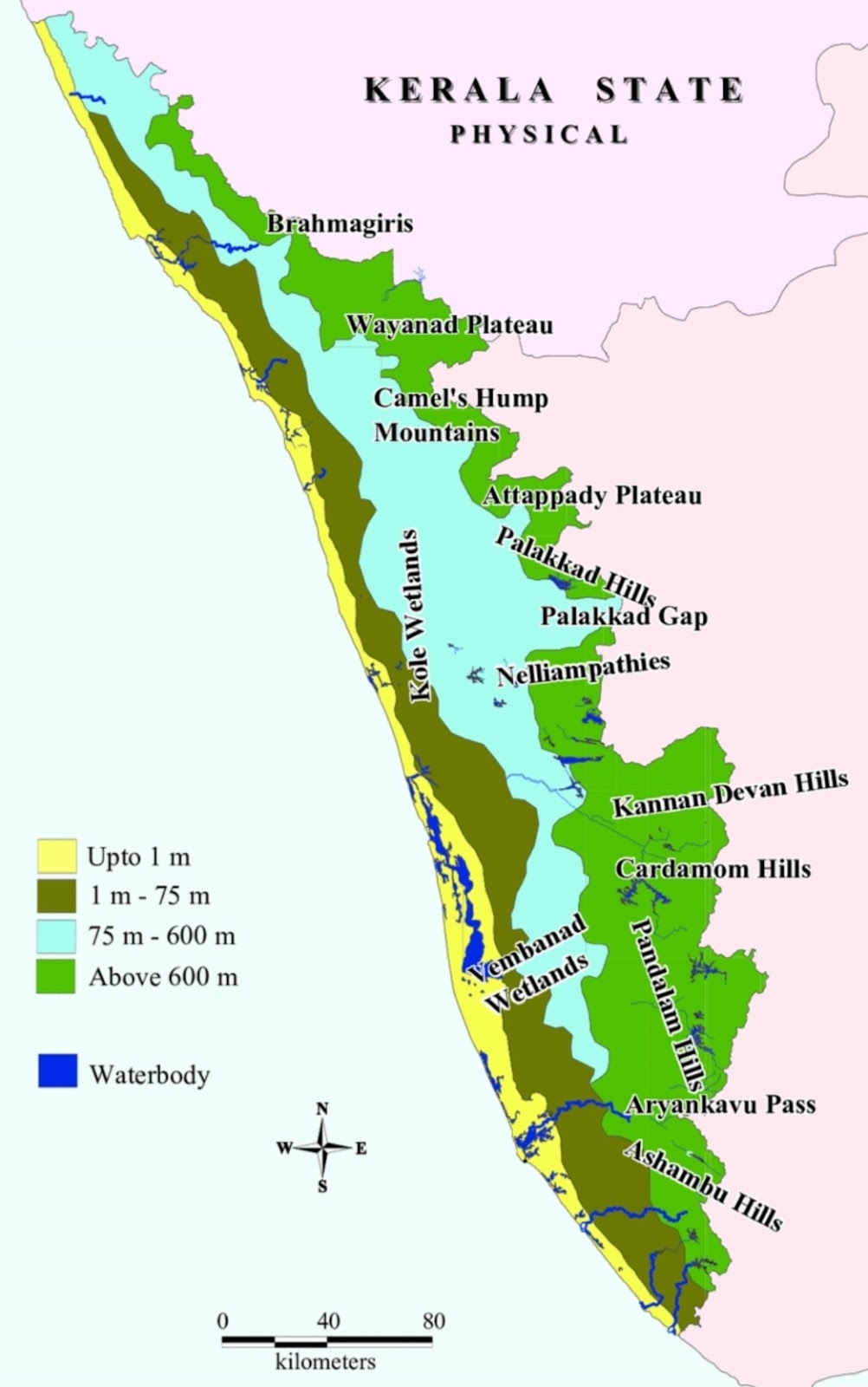
Kerala, known for its picturesque landscapes, ranges from the low-lying coastal areas to the towering heights of the Western Ghats. The diversity in elevation across the state means that different regions face distinct challenges, particularly in terms of safety from natural disasters like flooding and landslides. Based on the physical map of Kerala, which highlights the varying elevations, one can discern which areas are safer for habitation, especially when considering the threats posed by sea-level rise and landslides.
#### Coastal Plains and Lowlands (Up to 1 m - 75 m)
The coastal areas of Kerala, marked in yellow on the map, are characterized by elevations ranging from 1 meter to 75 meters above sea level. These regions are densely populated and include major cities like Kochi, Thiruvananthapuram, and Kozhikode.
**Safe Areas:**
- **Thiruvananthapuram:** As the state capital, it offers a relatively safer environment in terms of elevation, though certain low-lying areas within the city are prone to flooding.
- **Alappuzha and Ernakulam:** While these districts are vital commercial hubs, they are more vulnerable to flooding, especially during the monsoon season. Elevated parts of these cities, however, provide safer living conditions.
**Hazards:**
- **Flooding:** The primary concern in these low-lying areas is the potential for flooding, exacerbated by heavy rainfall and rising sea levels due to climate change. Residents need to be vigilant during the monsoon season, and homes built on elevated platforms or stilts can mitigate flood risks.
#### Midlands (75 m - 600 m)
The midlands, marked in light green, range from 75 to 600 meters above sea level. This zone is a transition area between the lowlands and the highlands, offering a balance between safety and accessibility.
**Safe Areas:**
- **Palakkad:** Known as the granary of Kerala, Palakkad has a mix of fertile plains and hilly terrain. The Palakkad Gap, a natural pass in the Western Ghats, provides this district with a unique geography that is less prone to landslides but still enjoys the benefits of higher elevation.
- **Kottayam:** This district, home to the famous backwaters, is situated in the midlands and is relatively safe from both flooding and landslides. The higher parts of Kottayam offer scenic views and a comfortable elevation.
**Hazards:**
- **Localized Landslides:** While less common than in the higher Western Ghats, certain steep areas in the midlands may still be prone to landslides, especially after prolonged rainfall.
#### Highlands (Above 600 m)
The highlands of Kerala, marked in dark green, are part of the Western Ghats, an ancient mountain range that runs parallel to the western coast. These regions are known for their lush forests, tea plantations, and cooler climates.
**Safe Areas:**
- **Munnar (Idukki District):** Known for its tea gardens, Munnar is a popular hill station. Although the area is above 600 meters, certain parts of Munnar are relatively safe from landslides due to stable terrain and well-maintained infrastructure.
- **Wayanad Plateau:** Wayanad, located in the northern part of Kerala, offers a cooler climate and stunning landscapes. The plateau areas are generally safer from landslides compared to the steep mountain slopes.
**Hazards:**
- **Landslides:** The steep slopes of the Western Ghats are highly susceptible to landslides, particularly during the monsoon season. Districts like Idukki and Wayanad have witnessed devastating landslides in recent years. Residents in these areas must take precautions, such as avoiding construction on unstable slopes and ensuring proper drainage to reduce the risk of soil erosion.
### Conclusion
Kerala's diverse geography offers a range of options for safe living, depending on one's preference for elevation and proximity to the coast. While the low-lying coastal plains are at risk of flooding, the midlands provide a safer alternative with their moderate elevation. The highlands, although beautiful and cool, require careful consideration due to the increased risk of landslides in certain areas.
For those looking to settle in Kerala with safety as a priority, the midland regions, particularly in districts like Palakkad and Kottayam, offer a balanced mix of elevation and accessibility, making them some of the safest places to live.
Comments
Post a Comment